


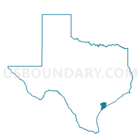
Voting District 0005, Calhoun County, Texas
About
Outline

Summary
| Unique Area Identifier | 671287 |
| Name | Voting District 0005 |
| County | Calhoun County |
| State | Texas |
| Area (square miles) | 33.25 |
| Land Area (square miles) | 30.23 |
| Water Area (square miles) | 3.02 |
| % of Land Area | 90.92 |
| % of Water Area | 9.08 |
| Latitude of the Internal Point | 28.52678550 |
| Longtitude of the Internal Point | -96.62852300 |
Maps


Graphs
Select a template below for downloading or customizing gragh for Voting District 0005, Calhoun County, Texas


Neighbors
Neighoring Voting District (by Name) Neighboring Voting District on the Map
- Voting District 0004, Calhoun County, TX
- Voting District 0006, Calhoun County, TX
- Voting District 0008, Calhoun County, TX
- Voting District 0020, Calhoun County, TX
- Voting District 0021, Calhoun County, TX
- Voting District 0023, Calhoun County, TX
- Voting District 0024, Calhoun County, TX
- Voting District 0025, Calhoun County, TX
Top 10 Neighboring County Subdivision (by Population) Neighboring County Subdivision on the Map
- Port Lavaca CCD, Calhoun County, TX (14,769)
- Seadrift CCD, Calhoun County, TX (3,888)
- Kamey-Sixmile CCD, Calhoun County, TX (1,270)